
Contents
How can you get started quickly? (reminder)
How do you navigate SkyViews?
How is each satellite view different?
What does your browser need to be able to do?
How do you make sure you are viewing the latest images and information?
What are some other hints to maximize the effective use of SkyViews?
What is the discussion forum and how does it work?
How can you get started quickly?(Up)
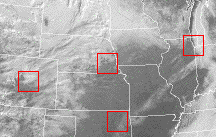 Choose a current satellite view (Visible, Infrared, or Water Vapor) from the navigation panel at the left of the screen. Then click on one of the red squares to reveal a current ground-based snapshot of that location's weather. Textual weather data will appear first at the top of the window, then an image of the sky from an automated camera.
The discussion forum will let you interact with others who are interested in the weather as seen through this "Atmospheric Field Trip".
How do you navigate SkyViews?(Up)
The section to the left of the screen is the SkyViews navigation panel. It is the key to getting around in SkyViews. The navigation panel will always remain on your screen allowing you to select any of the different imagery types and features:
- Satellite Views
- Visible: Brings an interactive visible light satellite image into the main window. This image was formed by the collection of light in the visible portion of the electromagnetic spectrum. This type of image shows where it is light and where it is dark.
- ---Supersize visible: Brings a non-interactive version of the visible spectrum satellite image into the main window. It is a very large file because of its high resolution. It takes some time to download.
- Infrared: Brings an interactive infrared light satellite image into the main window. This image was formed by the collection of light in the infrared portion of the electromagnetic spectrum. This type of image shows where it is warm and where it is cold. Note the temperature scale at the top of the image that is keyed by color.
- ---Supersize infrared: Brings a non-interactive version of the infrared light satellite image into the main window. It is a very large file because of its high resolution. It takes some time to download.
- Water Vapor: Brings an interactive water vapor satellite image into the main window. This image was formed by the collection of light in a portion of the electromagnetic spectrum that is sensitive to water vapor in the upper atmosphere. This type of image shows where it is moist and where it is dry. The lighter the color, the more water vapor is in the upper atmosphere at that location.
- ---Supersize water vapor: Brings a non-interactive version of the water vapor satellite image into the main window. It is a very large file because of its high resolution. It takes some time to download.
- Water Vapor Animation: Brings an animated gif image into view in the main window. It shows the motion of the atmosphere over time.
- Six Variable Data Graphic: Brings an colorful six-panel graphic into view. Each panel is color-coded to display a different weather variable.
- Support Information
- Background Information: Causes this document to appear in the main window.
- SkyViews discussion: An electronic bulletin board has been created to discuss SkyViews and the weather it focuses upon. Threaded discussions on various weather topics can be initiated.
- Let Us Know!: An opportunity to give direct feedback about Skyviews to the webmaster.
- SkyViews In Action:Offers focused learning activities that utilize the SkyViews interface. Just getting started here...
- SkyViews Credits: Brings a list of data and image contributors whose work makes SkyViews possible. Many different sources provide imagery and data for SkyViews. This link brings up a listing of these sources with links to their individual home pages.
How is each satellite view different?(Up)
- The visible images are formed by the collection of light in the visible portion of the electromagnetic spectrum (the light that we can detect with our eyes). This type of image shows where it is light and where it is dark--usually the result of different amounts of exposure to the sun's light.
- Infrared images are formed by the collection of light in the infrared portion of the electromagnetic spectrum (a type of light that our eyes are not able to see). This type of image shows where it is warm and where it is cold. Note the temperature scale at the top of the image that is keyed by color.
- Water Vapor images are formed by the collection of light in a portion of the electromagnetic spectrum that is sensitive to water vapor in the upper atmosphere. This type of image shows where it is moist and where it is dry. The lighter the color, the more water vapor is in the upper atmosphere at that location.
- Note: Supersize versions of each image are also available through the Navigation Panel. These images are quite large and offer a much more detailed view. They do not, however, offer the interactive ability to leap directly to the ground-based weather view.
What does your browser need to be able to do?(Up)
Both Microsoft Explorer and Netscape Navigator should display SkyViews sucessfully if they are recent enough versions to be capable of handling JavaScript and frames.
How do you make sure you are viewing the latest images and information?(Up)
Make sure you always reload/refresh the page or frame in order to get the most current imagery and data.
What are some other hints to maximize the effective use of SkyViews?(Up)
You will want to maximize your window size--hiding toolbars and location boxes can be a big help as well.
It is also important to use SkyViews on a regular basis. Checking the weather daily will hopefully begin to develop an intuitive sense for what is going on the atmosphere.
What is the discussion forum and how does it work?(Up)
The SkyViews Discussion Forum is intended to serve a meeting place to discuss satellite imagery and U.S. weather. Previously posted messages can be read by selecting a thread (a topic) and then selecting an individual message.
New messages can be added to the discussion by clicking upon the POST graphic. At that point there will be areas for your name, email address, subject, and message. Click on SEND when you are ready to post.
Copyright 1996 (original work and SkyViews concept only). P.D. Lindgren, Norfolk Public Schools. All Rights Reserved.
Comments to: lindgren@pluggers.esu8.k12.ne.us
All rights to satellite images, sky pictures, and textual weather data are obviously retained by their originators. Their work is gratefully acknowledged and applauded.
Last modified March 27, 1996.